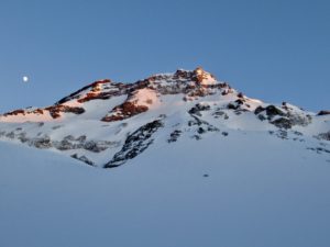
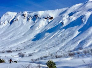
Tolhuaca Volcano From Laguna Blanca by Javier Embry
Route and photos by Javier Embry
Check the original story from Javier's blog.
Location:
Araucania, Malalcahuello
Elevation:
9206ft (2806m)
Lat/Long:
S -38.31512757146533, W -71.64864778518677
Vertical Skiing:
5905ft (1800m)
Route Duration:
Full Day
Volcanic Type:
Stratovolcano
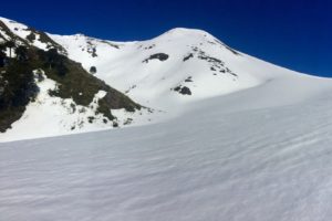
Gallery
Photo by Javier Embry (javierembry@gmail.com)Photo by Javier Embry (javierembry@gmail.com)Photo by Javier Embry (javierembry@gmail.com)Photo by Javier Embry (javierembry@gmail.com)Photo by Javier Embry (javierembry@gmail.com)Photo by Javier Embry (javierembry@gmail.com)
Previous
Next
Tolhuaca is the
Read More
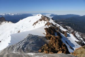
Cerro Colorado, Malalcahuello By @javier_embry
Cerro Colorado as seen from Volcan Lonquimay normal route.
Location:
Araucanía, Reserva Nacional Malalcahuello
Elevation:
6213ft (1894m)
Lat/Long:
S -71.57599210739136,
W -38.40152868655986
Skiing Aspect:
East
Vertical Skiing:
1420ft (433m)
Gallery
Cerro Colorado by Javier EmbryHalf way up by Javier EmbryLocal Splitboarder @naticorailLocal Splitboarder @naticorailLocal Splitboarder @naticorail with backcountry skier @nina_bognerLocal Splitboarder @naticorail with backcountry skier @nina_bognerFinal uphill looking towards Corralco valleyLocal Splitboarder @naticorail
Read More

Calbuco Volcano via Río Blanco
Location:
Southern Lake District - Reserva Nacional Llanquihue
Elevation:
6571ft (2003m)
Lat/Long:
S -41.33332031247092, W -72.61576652526855
Vertical Skiing:
5250ft (1600m)
Route Duration:
Full Day
Gallery
Previous
Next
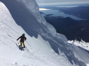
An overlooked volcano with a stunning view of the Estero de Reloncaví
The Calbuco is a very rarely skied stratovolcano, yet provides some of the most amazing thrills for those willing to make the 4 hour hike to
Read More
Cota-9 (Cerro Nueve) a.k.a Los Arenales
View from the normal route towards the cliff bands
Local Guides
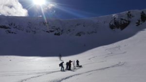
Gallery
Skining up thorugh the forest west of the normal routeThe back of Cota 9 towards North EastView from Cota-9 Summit to Lonquimay and TolhuacaView from Cota-9 Summit to Lonquimay and TolhuacaChutesLocal Skiers going for a 2nd lap from the cliff bandView
Read More
La Caída - Cerro Los Prados
Local Guides
Gallery
Previous
Next
Location:
Araucanía Region, Southern Andes. Malalcahuello
Elevation:
6175ft (1882m)
Lat/Long:
S -71.45224571228027,
W --38.6402044764171
Aspect:
East,South
Vertical Skiing:
1883ft (574m)
This enjoyable route is found along the route from Lonquimay to Icalma and is apt for everyone with a desire to experience peace in nature en route to a beautiful face filled with options. *We've tagged this zone La Caida
Read More
Yate Volcano
Photo by Camilo Novoa
Location:
Región De Los Lagos
Elevation:
7175ft (2187m)
Lat/Long:
S -41.75895591250358, W -72.39895820617674
Vertical Skiing:
To be Edited
Route Duration:
2 days 1 night
Volcanic Type:
Stratovolcano
Gallery
Photo by bitacorasdeviaje.clPhoto by bitacorasdeviaje.clPhoto by bitacorasdeviaje.clPhoto by bitacorasdeviaje.clPhoto by bitacorasdeviaje.clPhoto by bitacorasdeviaje.clPhoto by bitacorasdeviaje.clPhoto by bitacorasdeviaje.clPhoto by bitacorasdeviaje.clPhoto by bitacorasdeviaje.clPhoto by bitacorasdeviaje.clPhoto by bitacorasdeviaje.clPhoto by bitacorasdeviaje.clPhoto by bitacorasdeviaje.cl
Previous
Next
Climbing through native forest and finishing mostly over
Read More
Lonquimay Volcano South-SouthWest Access
Gallery
20 minutes into the traverse from the parking lotLocal Skier @randomaipo in the powdery bowl skiers right of this routeSunset seen from the southwest bottom of Loqnuimay volcanoSki touring back to the east sideSkintrack from the lower Araucaria forestBring your puffy jacket! That sun is not really warm in July - August
Read More